
It's Not Just You: Nor'Easters Really Have Gotten More Frequent And More Intense
By Peter Ciurczak
March 22, 2018
This is an online version of our Boston Research Snapshot email newsletter from March, 2018. Sign up to get the newsletter in your inbox every month.
After some milder stretches this winter, the Bay State has been battered with three nor’easters since the beginning of March. Two days into the official start of spring, and today’s storm is the fourth. Situated high on the eastern seaboard, Massachusetts is vulnerable to nor’easters, which form when warm air above the Atlantic meets the cold air above the east coast.
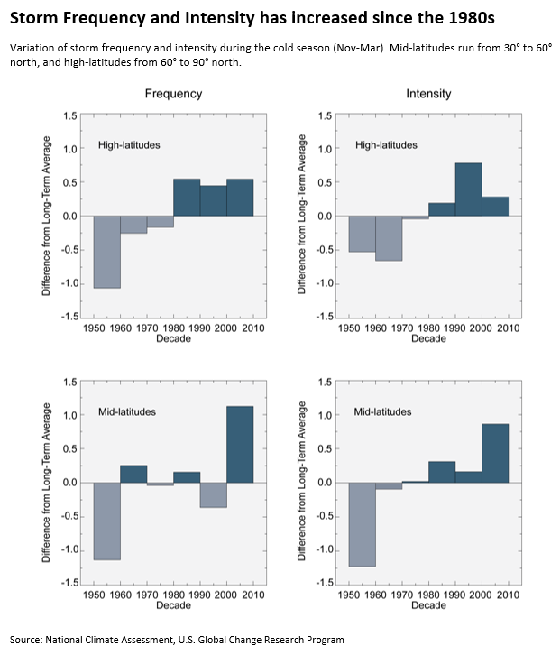
But our location doesn’t explain why winter storms would be increasing in frequency and strength. And indeed they have. Over the last 60 years, winter storms in the mid- and high-northern latitudes have become more frequent and more intense. At 42° north, Boston is in the mid-latitudes category (from 30° to 60° north), represented by the two bottom graphs.
Whether or not climate change is directly causing more frequent nor’easters (there just isn’t a lot of research on the subject), we do know that overall, extreme weather is becoming more common due to human-emitted greenhouse gasses. One consequence of our warming planet had a direct impact on the city's recent storms. Sea levels in Boston rose 9 inches over the course of the 20th century, helping the January 4th and March 2nd nor’easters to set the records for the highest and third-highest tides in city history, respectively. As sea levels continue to rise, each subsequent storm will begin from a higher starting point, likely setting new tidal records and increasing the prevalence of flooding. More powerful storms can also mean stronger storm surges, resulting in damage to seawalls and increased beach erosion. Storm surges flood low lying residences and businesses, and can backflow up drainage systems.
Into the future, Boston can expect to see continued and accelerating sea level rise, as well as an increase in severity of both heat and precipitation. From the recent average of 11 days per year with temperatures over 90 degrees (1978-2000), Boston may see as many as 40 days per year with temps over 90 degrees by 2030, and a potential for 90 such days by 2070. Likewise, the snowiest and rainiest days in the northeast are dropping more precipitation than they ever have before – a 70 percent increase between 1958 and 2010 – and this increase is projected to continue.
The City of Boston is moving forward in a number of different ways to better prepare for climate change. Recognizing that investing in mitigation is cheaper than rebuilding in the aftermath of extreme weather events, Boston is developing a series of neighborhood specific plans identifying strategies and infrastructure that can reduce the impact of extreme weather. Nevertheless, plans are only the first step toward protecting neighborhoods; they mean nothing if not acted upon.
- To check on the city's progress in meeting its Climate Ready Boston goals, check out the city's progress summary.
- To explore what impact climate change may have on Boston's neighborhoods under different scenarios, check out the Climate Ready Boston map explorer.